


Precise navigation meets global communication in the rugged GPSMAP 66I. The button-operated GPS handheld and satellite communicator (satellite subscription required) Comes preloaded with Garmin topo mapping and in reach technology, which enables two-way messaging and interactive SOS alerts.
From the manufacturer

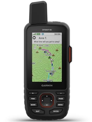
Garmin GPSMAP 66i
GPS Handheld and Satellite Communicator

NOTICE: Some jurisdictions regulate or prohibit the use of satellite communications devices. It is the responsibility of the user to know and follow all applicable laws in the jurisdictions where the device is intended to be used.
Rugged GPS Handheld and Satellite Communicator with Garmin TOPO Mapping
Precise Garmin navigation meets global communication in the GPSMAP 66i premium GPS handheld with inReach satellite technology.
- Large 3” sunlight-readable color display for easy viewing
- Trigger an interactive SOS to the GEOS 24/7 search and rescue monitoring center; two-way messaging via the 100% global Iridium satellite network (satellite subscription required)
- Preloaded Garmin TOPO mapping with direct-to-device BirdsEye Satellite Imagery downloads (no annual subscription); includes multiple Global Navigation Satellite Systems support and navigation sensors
- Cellular connectivity lets you access Active Weather forecasts and Geocaching Live
- Compatible with the Garmin Explore™ website and app to help you manage waypoints, routes, activities and collections, use tracks and review trip data from the field
- Internal, rechargeable lithium battery provides up to 35 hours of battery life in 10-minute tracking mode and 1-minute tracking mode (display off); 200 hours in Expedition mode with 30-minute tracking
Features and Benefits
| | |
|---|---|---|
Satellite CommunicationStaying in touch is vital, even on less challenging trips. Using inReach technology (subscription required), this handheld lets you trigger an SOS to the GEOS 24/7 emergency response team for interactive support in an emergency. It also enables two-way messaging and LiveTrack location sharing via the 100% global Iridium satellite network, so you can stay in contact with loved ones, teammates, headquarters and more. | Weather AnywhereWireless Cellular connectivity lets you access Active Weather for up-to-date forecasts, including predictive maps for temperature, wind, precipitation and clouds — right on the handheld when connected to Garmin Connect Mobile. | Pair with Your Mobile DeviceThe free Garmin Explore mobile app lets you plan, review and sync data, including waypoints, routes, activities and collections. Review completed activities while still in the field, even when you’re off the grid. The app also lets you sync your GPSMAP 66i with your compatible mobile device so you can access unlimited maps, aerial imagery and U.S. NOAA charts. You can even use all of the inReach features on your paired mobile device. For easier messaging, you can access your phone’s contact list from the Garmin Explore app to connect with fewer keystrokes. Plan for future trips and review previous activities from the Garmin Explore website. |


Important information
To report an issue with this product, click here.


tcp100 –
This is the first true full-featured GPS navigator with a satellite communicator built in. Realize what you’re buying into, and it’s a fantastic device.The original InReach devices were ostensibly marginal at being GPS navigators, that being a secondary trait of what they do. That isn’t the case with the 66i. The 66i has all of the top-of-the-line features of Garmin’s best handheld units.That being said, there has been a lot of talk of the “pros” and “cons” of this device. Let’s go through them one by one.1. Price: This thing is expensive for a GPS unit, but in my mind it is NOT expensive for what it does. I used to carry a Globalstar satellite phone when going in remote areas. That was a $350 phone with a $60/month plan – and it didn’t do much but make phone calls, and it wasn’t great at that. No location updates, no SMS. Purely for emergencies. Of course, I also carried a $350 eTrex at the same time. For $700 and $60/mo, I got SOME of the features that the 66i gives me in one device – for $600, $25/mo, and LESS WEIGHT, being key. Add in the weather reports (more on that below), location broadcast, and general utility of non-emergency SMS, and the utility is so much higher. All that and a better screen than the eTrex. Don’t compare the price of the 66i against one device, you need to compare it against two devices at once – a high end GPS AND a satellite communicator.2. Battery Life: The 35 hour claim is accurate, and Expedition Mode is a must. 20-30 minute track points are perfectly adequate, and you shouldn’t be leaving this on overnight anyway. You can get about 3-4 active days from the unit with moderate settings, and that’s good for most outings. Going longer? A simple power bank is something you should have with you anyways as essential gear.No, it doesn’t take AAs. Outdoors folk seem to have this obsession with AA batteries. 15-20 years ago it made sense, but it just doesn’t anymore and people need to change their mindset. I also carry a flashlight with a lithium battery and USB charging port (Acebeam and Thrunite have excellent models) that is brighter and lighter than an old fashioned AA model. The long and short of it is this: AA batteries have extremely poor power density. The power density (power per gram) of lithium simply isn’t beatable. 35 hours on the 66i can be doubled with juice to spare for other devices by taking along a power bank. That power bank is the equivalent of 20-30 AAs. Lighter, less weight, more power, more versatility. Cheaper after a couple of outings, too. The battery life of the 66i is perfectly good considering you can easily charge it back up overnight and go another 3-4 days. By the way, the issue is that this thing transmits – hundreds of miles into space – whereas your ordinary GPS is only a receiver. This takes an order of magnitude more power than receiving. A lithium rechargeable is the only practical way to go, and life will depend on how often you transmit.3. Firmware: Garmin is working on merging their acquired InReach (from DeLorme) infrastructure into their own. The 66i is the first unit released after that transition started, and it’s intended to be a native Garmin device. With that, some software features were delayed. These have now mostly ALL been fixed. You CAN now receive weather over InReach. The branding (“InReach Weather” vs “Active Weather”) is a little confusing – but all you need to know is the first is satellite and is text/table based, and the second is WiFi or via your phone Bluetooth and has radar maps. Radar maps are not currently a thing over satellite – but the detailed hourly satellite forecast is nearly as useful, as it derives from DarkSky which specializes in “hyper local” weather.Expect continued firmware updates, as Garmin has historically been excellent about this (the 66i is the 14th Garmin device I’ve owned over 25 years) – and make sure to keep your device up to date. I always check for updates a couple of days before I go out.4. Multi-GNSS: This is a little confusing right now, but as someone who actually works in the satellite industry and has specifically worked on the GPS program, I hope I can clarify a little. Right now there are four primary satellite navigation systems out there, each with their own satellite constellations run by different govenrments. The USA’s GPS is obviously the oldest, but there is also Beidou from China, GLONASS from Russia, and Galileo from the EU. GLONASS was the second system to be available to consumer devices, and Galileo is the most recent.Being more modern, Beidou and Galileo claim to have slightly better accuracy than GPS, but we’re talking a matter of a couple of meters. Additionally, the US’s GPS has traditionally been augmented by a secondary system, WAAS/EGNOS, which is a GPS accuracy enhancement system that largely makes up for that difference.In order to enhance reliability and accuracy, in the last few years consumer devices have supported receiving signals from multiple systems, as backup/redundancy and an accuracy enhancement.Whereas most early multi-system GPS’s supported GPS+GLONASS (such as the eTrex line), some now support there (the eTrex X series supports GPS+GALILEO+GLONASS). The GPSMap 66i supports GPS+GALILEO – but surprisingly to many, not GLONASS.In short: the reason this is the case according to Garmin is that the Iridium satellite network uses frequencies very close to that of GLONASS, and optimizing a receive / antenna system for GLONASS and Iridium proved too difficult. Even shorter: you’re not going to miss it.Yes, GLONASS is a more mature system than Galileo, but GPS+WAAS/EGNOS by itself is perfectly quick-acquiring and accurate by itself. Adding GALILEO makes this even more so, and as someone who literally builds radios for satellites for the military as his day job, a three-system unit is pretty much overkill. We’re talking literal inches here. You’re hiking, not flying a surgical strike with a drone. It’s not worth the battery drain.Could Garmin have done something like a dynamic notch filter to switch GLONASS on and off during iridium reception? Sure. Would it be worth cost, complexity and battery impact it could add to the device? No. You’ve already got a device that can use GPS, Galileo, WAAS, Iridium, Wifi and Bluetooth. That’s a lot of radios in one device, and it integrates them well.And last, some clarifications:- Garmin doesn’t word it well at all, but with the freedom plans you can suspend your subscription indefinitely. Their marketing material says you can suspend on a “monthly basis” which makes it sound like you have to sign in every month and suspend or it’ll renew again. That is not true. It stays off until you turn it back on. By “monthly basis” it just means that’s the smallest amount you’ll get charged for when you turn it on.- The ability to send preset messages that don’t count against your plan is huge. This will cover 80% of messaging use cases for most people I’d guess. You get three messages.. and you can attach your current location to all of them. Setting them to something like “Heading out” “Everything is OK” “Stopping for the night” covers most of your check-ins.- I have noticed a bug in the 5.90 firmware where the device restarts when switching WiFi networks or turning WiFi on and off. Not a big deal, but if you see it don’t think your device is broken.- The ability to download the BirdsEye imagery, which is free with the device (and got a major quality improvement in February) is super convenient. This lets you download without having to return home to a computer, so if plans change on the way, you can add images.- In addition to the built in topo maps, The 66i supports OpenStreetMap as well – which is gotten massively better in the past few years.- The SOS feature is backed by GEOS, an actual organization that coordinates rescues – so you aren’t just sending an SOS to your friends or to the local park ranger. This is a professional group. That being said, there is an option to pay $24.95 a year for $100,000 of “rescue insurance”, and options to upgrade for even more. If you’re the type of person who can justify this device, I’d highly consider it. It could save your financial life if you need to use it, and it supports an important organization if you do not.Summary: Overall, this is a wonderfully integrated and convenient unit with a few early-release quirks. It’sdefinitely not for the casual day-hiker and with so much technology integration, there is a learning curve. But that’s okay. The battery life is manageable and easily augmented, and the InReach feature can literally be a life saver. To be honest, this is the kind of device I had been waiting for. If you’re going to spend time in truly remote areas, I think it’s a must.
James Archer –
OK, waited for this to go on sale and jumped on it – did not really need it, but for the lower price < $400, why not. Basically, solid and works well, but I have had to reset it once after it locked up – hold down the power button for 30 seconds, which worked well and unit came back up. Is it as slick as your smart phone with TOPO maps, no, but why rely on one GPS?
Jon DeGraw –
As usual, Garmin exceeds expectations. The SOS function works perfect, as does the SMS feature. Lightweight and accurate.
Trey R –
I am on the fence about this device. It has profound pros and cons. On the plus side I will say that the screen resolution is very good for a device this size. It is well built. The accuracy is not too bad for a device at this price point. ( I would give the unit itself for stars) I highly recommend getting the silicone protective sleeve and screen protectors as protective measures. My main complaints with this device are: you have to install 2 separate Garmin apps to sync your device with your phone and backup and manipulate your way points. Syncing is accomplished through Garmin Connect while all other actions are conducted through Garmin Explorer. I’ve had significant difficulties getting the GPS to sync with my phone using the Bluetooth. Also maintenance of the connection is not reliable. I will say that when the devices do sink it’s very nice because you will get notification of text messages and phone calls on the GPS. If you don’t want that I suppose you could just turn off the Bluetooth.( I would give the apps one star) I tried to call customer support once but was on hold for an hour and when I get a person on the line they told me I had called wrong department and put me back on hold where I waited for another 20 minutes. I finally just hung up. ( I would give the customer service negative Stars if I could) Garmin customer service sucks. Be advised that this and probably all other handheld GPS units like it devour batteries. I suggest using rechargeable lithium or nickel metal hydride. The Birdseye satellite photos which you can download are hit and miss. Sometimes the photos will download just fine but other times it will prompt me to use the bird’s eye app which I have been unable to locate. Other times it will tell me that it’s an invalid file format. You have to use the high resolution setting on the photos otherwise they are too pixelated to be of much use. The SD card size is limited to 32GB which if you download many sat photos at high res will be devoured soon. In hi-res mode each photo is between 85 and 105 megabytes . So the bottom line is this; considering only the device itself I would buy it again but considering the device, related apps and crappy customer service I would probably look somewhere else. My star rating is skewed toward the unit and away from the apps and customer service. Cheers
Gene C –
Previously had inReach Explorer + – great device for emergency comm, light on GPS functions.The 66i is more GPS than emergency comm, can now be completely off the grid and have navigation, text communications and peace of mind.
Amazon Customer –
Super GerätDas Navi macht was es soll. Ausgepackt nach Norwegen gefahren und es hat top funktioniert. Kann ich nur empfehlen.
juan jose diaz –
calidad, tecnología de vanguardia.los productos Garmin son garantia y calidad, el articulo que seleccione se adapta a mis necesidades. estoy muy contento con el ya que me va a ser muy util en mis actividades off road.
Doug Schaefer –
GPS and Inreach reviewGreat GPS., easy to use and very easy to get the Inreach account set up. Battery seems excellent at this point but haven’t had it out in the field at this point, tested it over several days without shutting it off and it did great. Recommend the case
Amazon Kunde –
Erst am NordpoöIm Bereich vom Handyempfang bracht man so ein Teil wirklich nicht. Erst in der Arktis oder auf dem Himalaya nicht als ein Teil Sinn. Ach ja, für Geo Caching gibt es preisgünstigere Geräte
dogBoy –
Like an old Nokia cellphone.Sure it does the job, but the interface is so outdated it hurts.Screen is low resolution, difficult to read even on largest text setting.I owned it a year, used it a few times but never felt like I knew what it was doing.I’d get home, look for my tracks and find I had not started tracking. They should make it more obvious when this is on or off.Nope, just use your cellphone. Starlink’s around the corner and every man and his dog’s gonna have satellite connectivity in the next few years.This product is just a relic really. Don’t get me wrong, well built, long battery life, feels good in the hand but… meh!